|
|
Surveying I– coordinate accountPage takes part in the competition "Notes on the Internet" organized by the Rector of Academy of Science and Technology in Cracow. |
|||||||||||||||||||||||||||||||||||||||||||||||||||||||||
|
Analytical method for calculating the surface area of the polar coordinatesCalculate the surface area of the polar coordinates is dependent on the number of positions, from which measurements were made.
Search: Field P the polygon 1-2-3 calculate from formula:
|


| Point number | ki | di | didi+1 | ki+1 – ki |
| 1 | k1 | d1 | d1d2 | k2 – k1 |
| 2 | k2 | d2 | d2d3 | k3 – k2 |
| 3 | k3 | d3 | d3d1 | k1 – k3 |
| 1 | k1 | d1 | _ | ∑1n (ki+1 – ki) |
⇒ If the lengths and directions to points of the contour collapse were measured from several observation stations (Figure 2) we need to know the coordinates of the observation stations. Then we calculate coordinates of a collapse contour points:
Xi = XS + dicosASi
Yi = YS + disinASi
Continuation of the calculations performed of the Gauss's formulae*.
*If you do not remember how to calculate the surface area of the Gauss's formulae, click ![]()

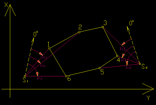
Figure 2. Location points 1-2-3-4-5-6 in the collapse of a contour in coordinate system
Note: To be able to calculate the surface area of the polar coordinates measured from several observation stations, the observation stations must be in one coordinate system.
- Example
-
Calculate the surface area of a polygon 1-2-3-4.
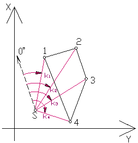
Measured length:
d1 = 123,32m
d2 = 153,74m
d3 = 147,35m
d4 = 98,56m
Directions reduced:
k1 = 40g,0300
k2 = 62g,1193
k3 = 89g,2873
k4 = 111g,4289
SOLUTION
Point number ki di [m] didi+1 [m2] ki+1 – ki 1 40g,0300 123,32 18959,217 22g,0893 2 62g,1193 153,74 22653,589 27g,1680 3 89g,2873 147,35 14522,816 22g,1416 4 111g,4289 98,56 12154,419 -71g,3989 1 40g,0300 123,32 _ ∑ = 0
2P = ∑1n didi+1sin(ki+1 – ki)
2P = 18959,217•sin(22g,0893) + 22653,589•sin(27g,1680) + 14522,816•sin(22g,1416) + 12154,419•sin(–71g,3989)
2P = 9825,466m2
P = 4912,73m2 ≈ 49,13a ≈ 0,4913ha
Views


This track is available on licencji Creative Commons Attribution-NonCommercial-ShareAlike 3.0 Unported.
Created by Justyna Jurek